Trail Walking La Celle-Saint-Cloud - De La Celle Saint Cloud à la forêt de Marly le Roi - Photo

De La Celle Saint Cloud à la forêt de Marly le Roi

 tracegps
tracegps

User

© OpenStreetMap contributors
Length
Length
22 km
Max alt
Max alt
190 m
Uphill gradient
Uphill gradient
434 m
Km-Effort
Km-Effort  
28 km
Min alt
Min alt
97 m
Downhill gradient
Downhill gradient
434 m
Boucle
Boucle
Yes
Creation date :
2014-12-10 00:00:00.0
Updated on :
2014-12-10 00:00:00.0

(0 Reviews)

Walking
Walking
4h30
Difficulty : Difficult

Scan this QR Code to open this trail in the SityTrail application

FREE GPS app for hiking

Logo SityTrail SityTrail

IGN / Geographical institutes

Download SityTrail from the App Store Download SityTrail from Google Play

Logo SityTrail SityTrail World

The world is yours!

Download SityTrail from the App Store Download SityTrail from Google Play Download SityTrail on Huawei AppGallery

About

Trail Walking of 22 km to be discovered at Ile-de-France, Yvelines, La Celle-Saint-Cloud. This trail is proposed by tracegps.

Description

Circuit proposé par le Comité Départemental de Randonnée des Hauts de Seine. Point de départ : La Celle-Saint-Cloud, Pavillon du Butard Descriptif : GRP, Pavillon du Butard, forêt de Fausses-Reposes, parcelle 19 ... nb, route aux Bœufs, Bel-Air, le Chesnay parc du château, Rocquencourt, Forêt de Marly porte de Rocquencourt, Camp de Voluceau, les Hauts de Bailly, Porte de Bailly, Porte Criton, , carrefour de la croix Saint Philippe ... nb, tunnel A13 … GR1, gare de l'Etang-la-Ville … GRP parc de Marly, Louveciennes, Forêt de Louveciennes, gare de Bougival … nb, La Celle-Saint-Cloud … GR1, bois de la Celle, Pavillon du Butard. Des sentiers ont pu être modifiés depuis la dernière validation et les itinéraires proposés n’engagent pas la responsabilité du Comité. Signalez-nous les modifications rencontrées pour mise à jour de la randothèque.

Elevation profile

Photos

Positioning

Country:
France
Region :
Ile-de-France
Department/Province :
Yvelines
Municipality :
La Celle-Saint-Cloud
Location:
Unknown
Start:(UTM)
437234 ; 5409973 (31U) N.

Trails nearby

Trail Walking Chaville - Le Sentier des 7 étangs - Photo
Walking
tracegps

Walking

Difficult
(5)
Chaville, Ile-de-France, Hauts-de-Seine, France
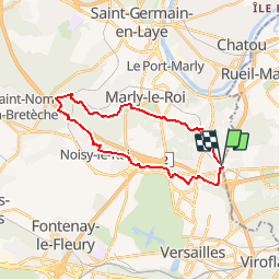
23 km | 31 km-effort
5h 0min
Yes
Trail Walking Bougival - Bougival-Saint-cucufa reel - Photo
Walking
perlimpinpin59

Walking

(1)
Bougival, Ile-de-France, Yvelines, France
7.7 km | 10.3 km-effort
2h 29min
Yes
Trail Walking Viroflay - Les 3 Forêts; Meudon, Fausses Reposes et Versailles - Photo
Walking
tracegps

Walking

Difficult
(2)
Viroflay, Ile-de-France, Yvelines, France
25 km | 32 km-effort
5h 19min
Yes
Trail Walking Chaville - Sentier des deux Forêts - Meudon et Verrières - Photo
Walking
tracegps

Walking

Difficult
(2)
Chaville, Ile-de-France, Hauts-de-Seine, France
23 km | 29 km-effort
5h 0min
Yes
Trail Other activity Versailles - Parc de Versailles - Photo
Other activity
irokoitennis

Other activity

Very easy
(1)
Versailles, Ile-de-France, Yvelines, France
8.9 km | 9.7 km-effort
1h 49min
Yes
Trail Cycle Chaville - chaville - maison lafitte - Photo
Cycle
Letizia

Cycle

Medium
(1)
Chaville, Ile-de-France, Hauts-de-Seine, France
44 km | 50 km-effort
3h 27min
No
Trail Mountain bike Chaville - grand circuit VTT - Photo
Mountain bike
macleon

Mountain bike

Very easy
(1)
Chaville, Ile-de-France, Hauts-de-Seine, France
32 km | 40 km-effort
Unknown
Yes
Trail Walking Vaucresson - GRP CV-IDF 2023 - Photo
Walking
clalaur

Walking

Easy
Vaucresson, Ile-de-France, Hauts-de-Seine, France
11.9 km | 15.3 km-effort
3h 29min
No
Trail Walking Versailles - Pièce d'eau des Suisses - Photo
Walking
mallovon

Walking

Easy
Versailles, Ile-de-France, Yvelines, France
4.2 km | 5.2 km-effort
1h 12min
Yes


Close
My subscriptions